
Parker Consults is a professional soil science consulting firm located in Franklin, Pennsylvania. We provide soil science and environmental science consulting services throughout western Pennsylvania and eastern Ohio. Neal Parker, Senior Soil Scientist/Owner of Parker Consults, has over forty years’ experience in soil science and resource management to serve our clients’ needs. Parker Consults primarily serves engineering firms needing a high level of expertise. We work in the natural gas drilling industry, and with large corporate clients as well as private property owners. We specialize in the following areas:
Soil Science Investigations:
Storm Water Management – soil profiling and infiltration tests to assist in determining infiltration area sizes and capacities.
On-Site Sewage Disposal – soil profiling to determine the limiting zones for effluent absorption.
Sewage Sludge Disposal – soil mapping and disposal planning for the safe application of sludge.
Solid Waste Disposal – soil mapping and disposal planning for the safe application of solid waste.
Land Reclamation and Remediation – soil mapping and planning for land reclamation including mine sites, brownfields, and urban areas.
Archeological Investigations – soil mapping and profile investigations to assist archaeologists.
Agricultural Nutrient Management – soil mapping and disposal planning for the safe application of agricultural waste management.
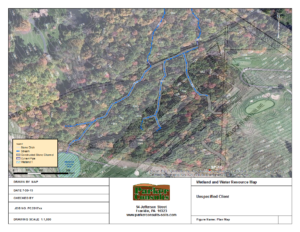
Wetland Delineations and Mitigation Planning/Permits:
Routine Wetland Delineations – thirty years of wetland delineations as a USDA Natural Resources Conservation Service conservationist and nine years in the private sector.
Wetland Delineations for Problematic and Atypical Wetland Situations – specialization in wetland situations that require additional levels of expertise compared to the routine wetland procedures.
Riparian Assessments and Mitigation Planning/Permits – specialization in riparian site assessments, stream evaluations and riparian mitigation plans.
GIS Advanced Mapping Services:
GIS Mapping integrating client’s engineering plans
ArcGIS Mapping – Parker Consults has over nineteen years’ experience in advanced GIS mapping. We use the latest ESRI ArcGIS/ArcMap technology. Neal Parker has over forty-four years’ experience in mapping, beginning as a terrain analyst/geographic intelligence specialist in the US Army in 1973. He is experienced in cartography, photo interpretation and remote sensing.
Site Surveys – Parker Consults also uses the Trimble InSphere Terraflex data collection web-cloud and Trimble R1 GPS system/iPhone Terraflex Mobile app. This allows us to manage real time sub-meter accurate field data online, provide field data directly to the client, and integrate it into ArcGIS mapping.
Terraflex
Drone Service Support – Parker Consults also has aerial drone service available through a partnership that provides accurate resource assessments that can be integrated into the ArcGIS mapping to support the above services.